 By admin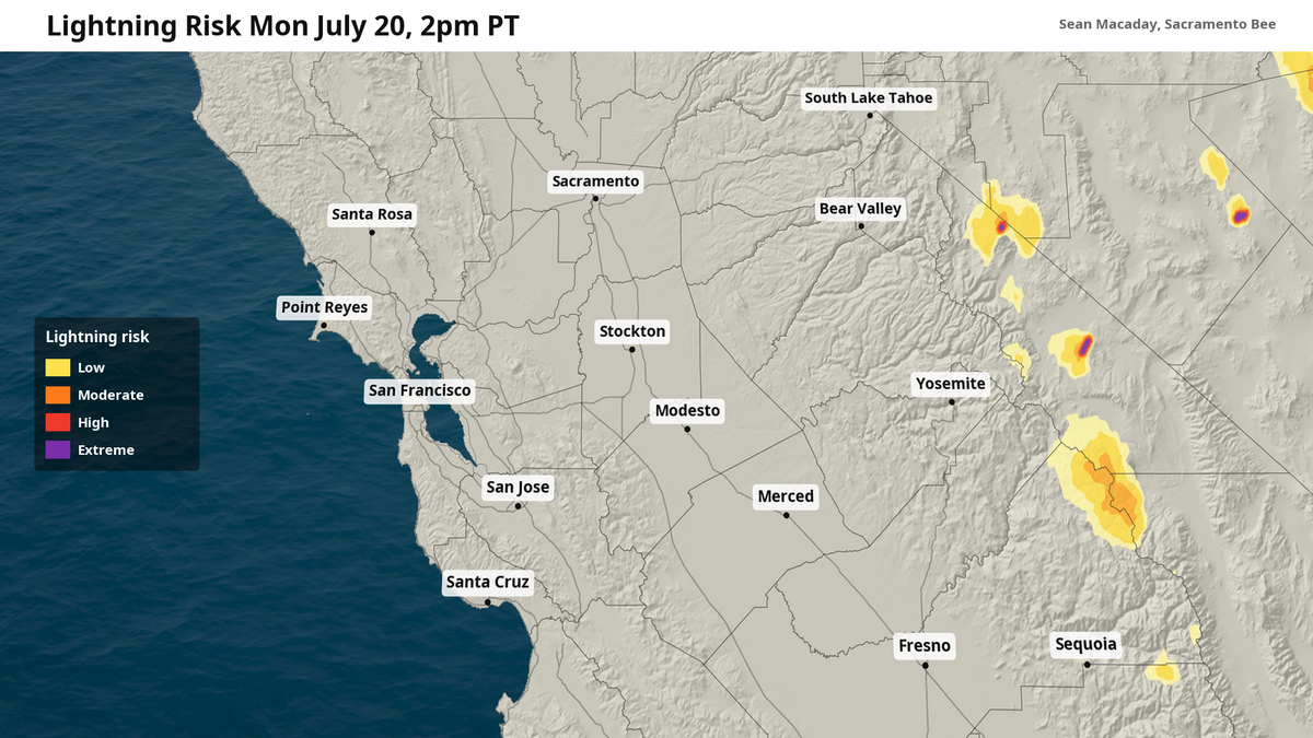
Due to a kick of monsoonal moisture from what is left of Tropical Storm Elida, thunderstorms will pop up across the Sierra Nevada Monday and Tuesday, brining with them a risk of flash flooding and lightning.
Read more Lawsuit alleges El Dorado County Jail failed to protect inmate from assault
As what is now post-tropical cyclone Elida nears northern California, the shield of moisture on its eastern flank is dragged north across the entire state. This meant extra clouds Monday across the area and a bit more humidity.
Thanks to this moisture coming out of the south, we can correctly call this another plume of the summer monsoon. And this plume in particular is the strongest so far, with a potential for real measurable rainfall across the Sierra alongside lightning and strong winds.
As of early Monday afternoon, thunderstorms were already ongoing along the Sierra Crest in Mono County, with the potential to expand further northward towards Lake Tahoe by the late afternoon.
Thanks to the high moisture content, any thunderstorms that do pop, especially on Tuesday, will be capable of ample lightning, one-inch-per-hour rainfall rates, and 50+ mph wind gusts. Storms will be slow-moving out of the southeast, meaning the rain that does arrive will come from a stacked weather system that will increase flash flooding risks in localized spots.
Tuesday – stronger thunderstorms and more pronounced flood risk
While Monday mountain thunderstorms will be more isolated, Tuesday storms are likely to be more widespread as Elida makes its closest pass to northern California.
Read more Placer County deputy narrowly avoids DUI driver while investigating hit-and-run
A Flood Watch has been issued for the high-altitude areas of Placer, El Dorado, Alpine, and Mono counties for Tuesday afternoon and evening, as well as the Reno, Nevada area.
Flash flooding will be quick as storms move slowly and compound on the mountainous terrain. Be aware of fast moving water along rivers and streams.
Meanwhile, storms could be strong to severe with wind gusts above 50 mph at times. Areas above the treeline will be more at risk for intense winds, so anyone at high-altitude should be aware that the winds could turn suddenly as the storms evolve.
Finally, lightning along the edges of these thunderstorms, where conditions remain dry, will pose a risk for wildfires. Widespread slow-moving systems, such as the ones expected Tuesday afternoon, are capable of more cloud-to-ground lightning than normal. If you hear thunder, move to a safe space indoors. If you cannot make it indoors, work to remove yourself from elevated areas such as hills or mountain peaks, and do not shelter under a tree.
Conditions for outdoor activities in the mountains improve Wednesday as the moisture fades and Elida weakens over colder Pacific waters.
Read more Where are the fires burning in Northern CA? Latest on Biscar, Rumsey, Chute fires
This story was originally published July 20, 2026 at 1:09 PM.