 By admin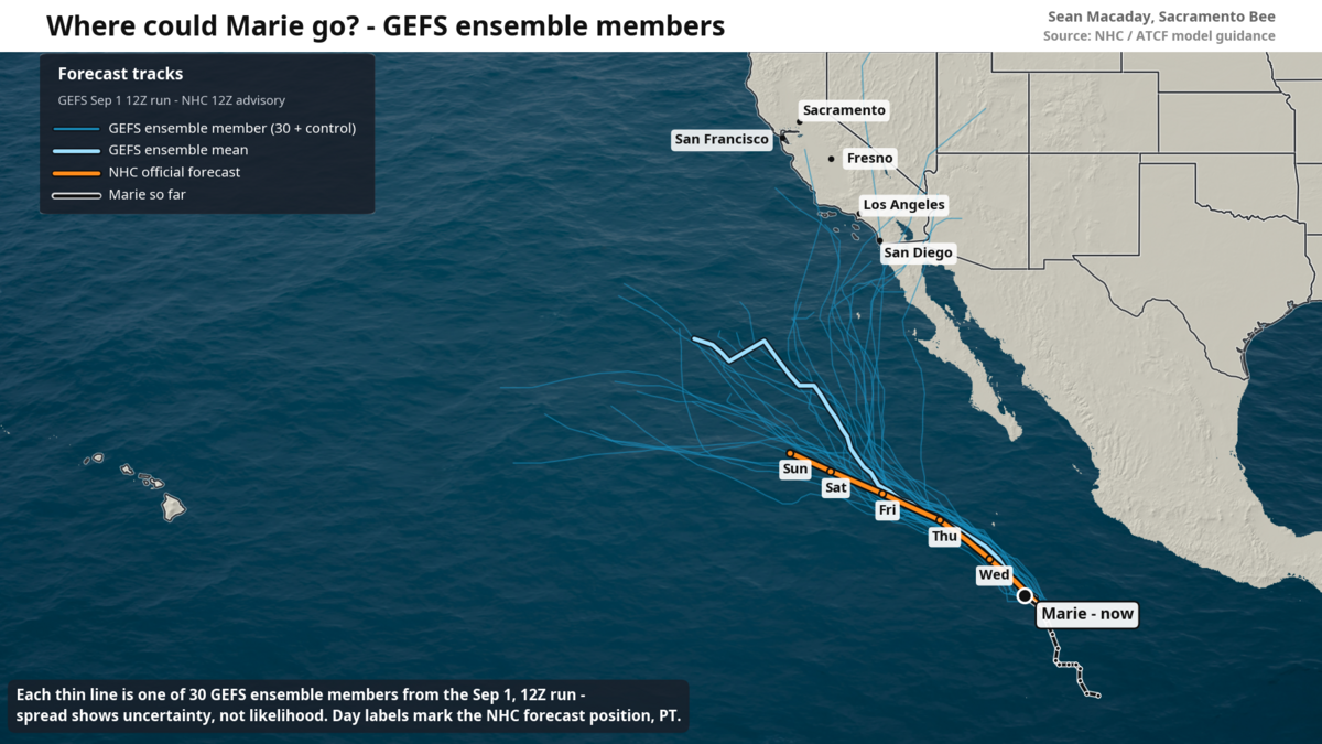
Tropical Storm Marie formed early Tuesday morning in the eastern Pacific just offshore of Mexico and well to the south of California.
Read more Lake Tahoe river otter attack leaves swimmer bloodied and needing 38 stitches
As of Tuesday afternoon, Marie had maximum wind speeds of 60 mph, and is forecast to strengthen into a Category 2 hurricane later this week according to the National Hurricane Center.
Due to a trough of cooler air that has brought an early taste of fall to the Golden State, this particular storm will pass closer to California than most storms of its type. As the pressure of the atmosphere is lowered across California this week, soon-to-be hurricane Marie will feel a sort of gravitational pull towards land thanks to it being a low pressure system itself.
And while many Californians will follow Marie over the coming week, temper your expectations about this storm’s capabilities.
Marie’s strength would weaken close to land
Headlines and social media are abuzz with statements that a hurricane is set to land in California later this week. Don’t believe the hype — at least not yet.
While there remains a smidgen of possibility for a direct landfall of what would be a weakening or post-tropical hurricane Marie Sunday or Monday, the far more likely scenario is one where Marie holds well offshore while bringing monsoonal showers and moisture to Southern California.
As Marie is pulled northward by a developing and deepening trough across the western U.S., it will begin to weaken and shed its shield of moisture in the form of weak and sporadic showers — most likely as occasional monsoonal storms across Arizona, Las Vegas and far Southern California.
And while the sea surface temperatures off the coast of Southern California are well above average for this time of year, they are not warm enough to support a strong hurricane. If Marie that veers too close to the coast it will weaken quickly. The “spaghetti models” — the lines of all possible forecasted paths of the storm — make a great visual, but they do not tell the story that any version of Marie that moves towards land will be a weaker one.
And even then it is more likely that Marie continues its march west out to sea. Across a blend of 64 different ensemble members, different runs of a weather model with slightly different initial conditions, only a minority brought appreciable rainfall to Southern California.
Read more California e-bike bill could create sidewalk speed limit for all
The forecast will continue to improve as Marie draws closer. Until then, the reasonable expectations for California will be increased surf along the coast, a few showers in SoCal, and some beautiful sunsets across Central and Northern California this weekend as Marie’s cloud deck draws in view.
The hype surrounding #Marie is too high, largely thanks to a few single runs of deterministic models.
On the left, the average of Google’s WeatherNext2 64 ensemble members. Not much rain for SoCal, but a few showers from monsoonal moisture in some scenarios.
On the right, a… pic.twitter.com/SI4eKIyAyr
— Sean Macaday (@MacadayWX) September 1, 2026
Hurricanes in eastern Pacific boosted by El Niño warmth
El Niño works to both increase sea surface temperatures across the eastern Pacific Ocean — providing more fuel for eventual hurricanes — and the rising motion of the atmosphere near the Americas. This combination is potent, priming the environment in the east Pacific for hurricane development and maintenance more than during non-El Niño years.
And given that this El Niño has the potential of being the strongest on record, it is no surprise that the east Pacific has been a constant stream of hurricanes (and also that the Atlantic has been essentially closed for months).
In late July, Hurricane Genevieve roared into a monster Category 5 east of Hawaii. Two weeks later, and Hurricane Lala dropped upwards of 20 inches of rain on portions of the Big Island. And just last week, decaying Tropical Storm Iselle left plenty of tropical moisture to rain across Central California.
Alongside Marie, the east Pacific is also currently home to Category 4 Hurricane Karina and Category 1 Hurricane Lowell — which are both pushing west and will draw closer to the Hawaiian Islands later this week.
After Marie waves goodbye to the Golden State, the eastern Pacific won’t slow down anytime soon. Expect to see storms Norbert and Odalys form over the coming weeks if not sooner.
And while it is exceptionally rare, tropical storms can indeed impact the western U.S. Several years ago, a weakening Hurricane Hillary led to intense rains in Death Valley and SoCal’s first ever tropical storm watch. With El Niño staying put through the rest of the year, every storm that forms will be worth a keen eye.
Read more Which bills affecting state workers passed in the legislature’s final days?