 By admin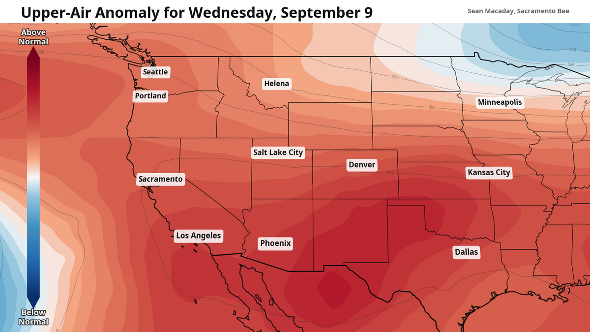
After a gorgeously cool start to September, with high temperatures 10 to 20 degrees below average last week across a large portion of the California, the Golden State is making another rendezvous with summer-like weather as we move past Labor Day.
Read more Derrell Roberts created a family center to provide safety and sense of community
Strengthened by Tropical Storm Marie, a ridge of high pressure through the upper atmosphere is forming across the western United States, increasing heat and clearing skies for much of this side of the nation through the week ahead.
On Tuesday, temperatures across the Central Valley — from Sacramento to Fresno — will rise into the mid-90s. They will continue climbing, rising above 100 degrees by Wednesday and Thursday as Marie continues to dredge up more moisture. Lows will also climb — temperatures around 70 degrees will greet commuters Wednesday and Thursday morning across the Central Valley.
Tropical Storm Marie is ushering in moisture and extra heat
The heat is not limited to just the Valley either. The Bay Area and the rest of the Central Coast will feel the heat, especially Wednesday as Marie’s moisture makes its closest approach. The mid-80s may seem rather nice, but temperatures this warm for the San Francisco are well outside of normal. And astonishingly even 90s are not out of the question for a majority of the Bay Area if enough tropical moisture is present.
Heat advisories have been issued for large portions of the state for Wednesday and Thursday, both in the Central Valley and along the entire California coast south of Marin County. This includes San Luis Obispo, Los Angeles and San Diego.
This all comes as Tropical Storm Marie’s moisture shield envelopes California this week. From south to north, dew points and atmospheric moisture will rise in tandem, brining unusual humidity to nearly the entire California coast. Because moist air holds more heat than dry air, temperatures will struggle to cool down overnight and along the coast as they otherwise would.
Read more Highway 50 closed near Rancho Cordova. Here’s how to get around it
Indirect impacts: Tropical Storm #Marie will drag tropical moisture and extra heat up across California over the coming days. Mid-90s possible for coastal SoCal, and 100+ degrees across the Central Valley Wed/Thu. #cawx pic.twitter.com/EmfUeOQcDl
— Sean Macaday (@MacadayWX) September 8, 2026
This humidity is already deep in play in Southern California, where a few pockets of the Los Angeles region saw upwards of an inch of rain Sunday and Monday as moisture arrived.
For the next few days in Southern California, dew points nearing 70 degrees will combine with temperatures in the 90s to produce feels-like temperatures above 100 degrees; disturbingly high levels of humidity akin to Miami or Houston in the height of summer.
Back in Central and Northern California, Marie’s moisture will not be felt as 70-degree dew points, but it will be seen as passing clouds across the region – marking that the peak of this heat wave is arriving and signaling some work for the air conditioner. Most of these clouds arrive on Wednesday, with a few lingering clouds Thursday as temperatures peak. A few sporadic showers — especially in the Sierra and Northern California — cannot be ruled out Wednesday evening, but don’t base any plans around that for now.
Cooler temps settle in this weekend and next week
Thankfully, these temperatures will fade. Marie will dissipate as it moves over cooler Pacific waters this week, and by the weekend the ridge of high pressure will begin to erode. Look forward to a more comfortable return to typical or even slightly below-average temperatures this weekend and next week. For much of the Central Valley, including Sacramento and Fresno, that means mid- to upper 80s and more clear skies.
Read more Tax increase or tax cut? What California’s Prop. 3 may mean for education funding