 By admin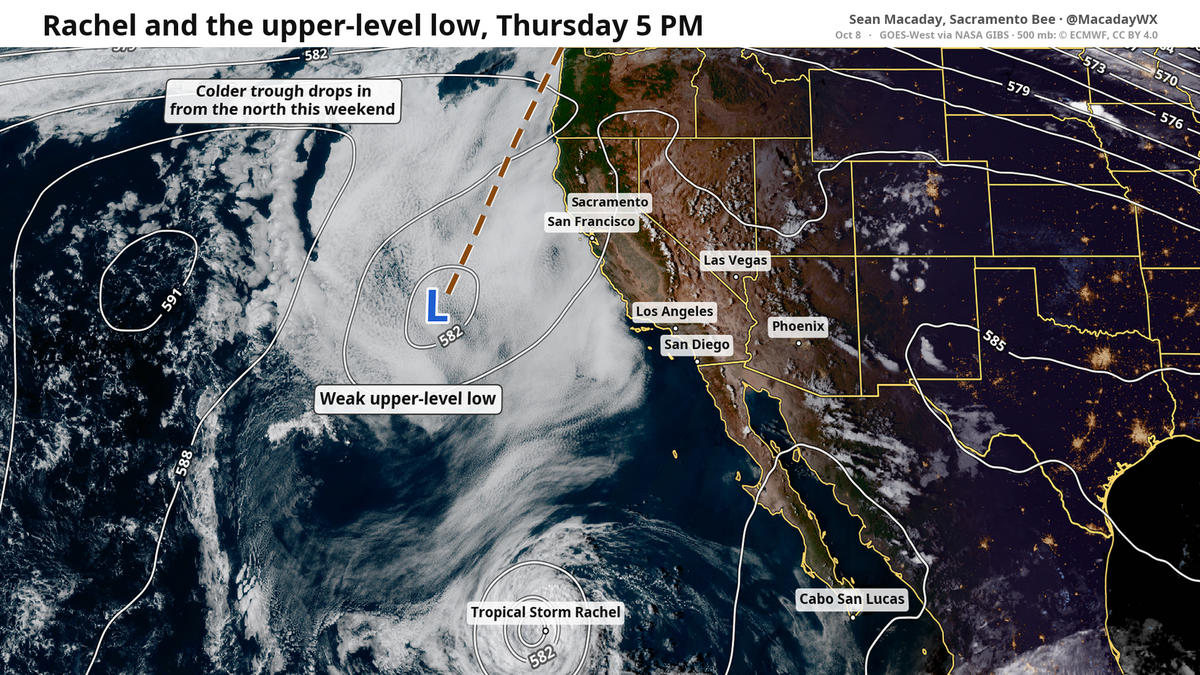
After more than a week of an intense heat wave, fall weather is finally here. Temperatures this weekend are about to take a nosedive, from the upper 90s across the Central Valley and Southern California down into the 70s or even lower. The phrase “fall breeze” comes from setups like this weekend.
Read more Fresno County contractor dies while hiking Mount Whitney: ‘Great loss for us all’
And a fall breeze isn’t all there is, a tropical storm will help squeeze out some raindrops worth keeping an eye on into early next week.
The cool down finally arrives
From the Pacific Northwest, a broad and deep area of lower pressure through the upper atmosphere — called a trough — is set to swing through between Friday and Monday, sweeping in cooler temperatures from the north to south as the weekend progresses.
First across northern California, high temperatures will begin to dip Friday as the trough approaches from the north. Highs in Sacramento will go from around 100 degrees on Thursday to 90 degrees Friday and all the way to 75 degrees Saturday and 70 on Sunday. A precipitous drop in a short timeframe.
Other spots across northern California will feel this as well. Redding drops from 94 to 77 between Friday and Saturday, and Santa Rosa drops from 81 to 69 degrees.
Across Central California, the drop is slightly delayed as the cool air moves in from the north slightly later. Modesto, Merced, and Fresno drop from the mid 90s on Friday to the low 80s on Saturday, and further down into the low 70s-by Sunday. It’s one day cooler after the next.
In Southern California, the drop-off really arrives between Saturday and Sunday, but Tropical Storm Rachel will be at work here also influencing the forecast. In San Luis Obispo, Paso Robles, and Santa Barbara, high temps will drop from the mid-70s to the 60s. Clouds from Tropical Storm Rachel will overtake all of Southern California Sunday from Merced and Fresno south, further cooling down temps.
Read more Idaho sisters lost touch as their family unraveled. Then police knocked on the door
As this trough of cooler low-pressure air arrives, let’s not forget that fall breeze. Winds across northern California will gust up to 30 mph Saturday even in open areas, and significantly higher at elevation. A fire weather watch is out for Saturday for Reno and portions of the Sierra including Bridgeport and Mammoth Lakes ahead of strong north winds and dry conditions.
Tropical Storm Rachel will fuse, produce rain early next week
That cold air trough that brings us the cooler weekend weather is also what will bring Tropical Storm Rachel ashore near Tijuana Saturday night, with impacts extending into Southern California across the border.
Rachel, being drawn like a golf ball rolling towards an easy hole in mini golf, is being pulled northward by this trough. Both are low pressure systems of their own, and they will fuse together Sunday into a much larger post-tropical cyclone that will empty scattered showers across Southern California and the Mojave.
Much of this energy will linger across California and Nevada on Monday as the cyclone expands into the jet stream. The result will be fleeting showers stretching all the way from northern California south through San Diego Monday, with heavier rain expected in the Sierra.
The Central Valley is likely to remain more dry than not, but rain will be easier to come by in the San Joaquin Valley and south to the San Luis Obispo-Santa Barbara coast. Nearly all showers will be lighter and short-lived, but the clouds will linger Monday with cooler autumnal temperatures to boot.
Here’s a bonus — this tropical fuse with the jet stream will be enough to string out some snow across the high peaks of the Sierra, with some even working down to places like South Lake Tahoe. Most snow will quickly melt, but it’s a sign of the times.
Read more Gov. Gavin Newsom reportedly mulls commuting all California death sentences