 By admin
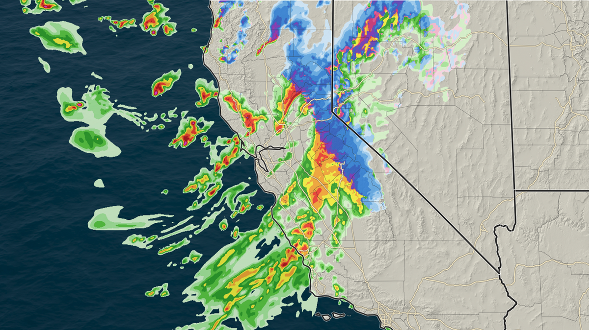
The third atmospheric river storm in less than a week will be the most impactful for California so far this season, with more rain, wind, thunder and snow to go around statewide.
Read more Storms set to deliver epic Sierra snow before Thanksgiving. See California forecast
This all comes as several inches of rain, and several feet of snow in the Sierra, have already fallen over the past week, with even more storms to come before Thanksgiving.
The deep trough of low pressure that has been situated offshore of Northern California and fueling the rain over the past week is about to kick into another gear. As it drifts south overnight Tuesday into Wednesday, it will dig into more energy — in the form of more heat and moisture — and wring out heavy precipitation statewide. The storm will strengthen during this process, driving hazardous wind gusts and the potential for severe thunderstorms through Thursday.
Wednesday morning: Strong winds, thunderstorms and heavy snow
The storm will first arrive to the North Coast Range late Tuesday as heavy showers and snow across the Klamath Mountains. By the early hours of Wednesday morning, the showers and storms are already moving into the Sacramento Valley.
Third storm in less than a week will be the most impactful so far. Scattered thunderstorms across the Central Valley and NorCal Wednesday alongside gusts to 45 mph (and 60 mph along the coast), with heavy rain lingering into Thursday. Several feet of snow in the Sierra will impact travel into Friday. #CAwx
— Sean Macaday (@MacadayWX) November 17, 2026
By mid-morning Wednesday, moderate-to-heavy rains will pour into the Sacramento region with winds gusting up to 50 mph. Over an inch of rain could fall quickly, so be prepared for roadway flooding and an impacted commute.
A wind advisory is in effect for the entire Sacramento Valley on Wednesday, with gusts reaching up to 60 mph in the Delta and foothills.
Wednesday afternoon: Thunderstorms, funnel clouds
The heaviest showers will continue pushing southeast, moving out of Sacramento by mid-afternoon and into the San Joaquin Valley through the rest of Wednesday. Expect impacted afternoon commutes in places like Fresno and Modesto. The Sacramento Valley will continue to see sporadic bouts of showers and even a few thunderstorms on and off through the remainder of Wednesday. Showers and storms in the San Joaquin Valley will continue on and off for most of Thursday.
With the central low pressure drawing closer on Wednesday, winds will begin to twist across Central California, allowing for the development of brief supercell thunderstorms capable of very heavy downpours, hail and even brief funnel clouds. Any severe thunderstorms that do develop will be short-lived.
Read more Placer County sheriff’s officials serve search warrant at Citrus Heights home
Above 4,000 feet, the storm will squeeze out immense amounts of snow as the low pressure deepens. The Sierra is primed for an epic start to ski season, but the storm will leave a lingering mark on travel as well.
A winter storm warning is out through Thursday for the Sierra in anticipation of several feet of snow. Winds gusting to 60 mph Wednesday and constant snowfall rates of more than an inch per hour will lead to white-out conditions and quickly deteriorating road conditions. The highest snowfall will occur above 6,000 feet, where one to five feet of snow is likely.
While the heaviest snow is set to fall late Wednesday across the central and southern Sierra, lingering weather through Thursday likely means that road conditions, including over the Donner Pass to Reno, could remain impacted into Friday or longer.
Thursday: Storm shifts towards SoCal, showers continue
The band of heaviest rain will move south into Southern California Wednesday night and through Thursday, impacting the morning commute from San Luis Obispo to Los Angeles.
Through the rest of Thursday, the storm will continue to squeeze out sporadic showers and thunderstorms as winds begin to slow. Heavy snow will continue across the Sierra, as a near perfect setup for extreme snow making in the southern Sierra dumps several feet on the highest peaks.
Rainfall totals in the Sacramento Valley by Friday morning are expected to be greater than 2 inches, with the Delta and Modesto regions seeing more than an inch and the far southern San Joaquin Valley getting just around an inch.
Rain totals will also be greater along the coast, with 2-4 inches falling between San Francisco to San Luis Obispo.
And while Friday will be a brief moment of calm for most of the Golden State, it doesn’t stop there. The fourth round of storms, thankfully weaker, will push into Northern and Central California late Saturday, and a fifth round will likely arrive just before Thanksgiving next week. Buckle up.
Read more California education department sued over data breach affecting millions of students
This story was originally published November 17, 2026 at 4:39 PM.