The coldest temps in nearly a month are on the way for Sacramento and much of Northern California.
Read more CA Democrats pitch ‘rainy day fund’ expansion. GOP warns more spending to follow
A strong upper atmospheric trough — an area of low pressure — has been developing over the past several days in the Gulf of Alaska. That trough is now making its push into the western United States. As it arrives, it will bring with it a strong cold front out of the northwest that will push temps well below average across much of interior California and the western U.S.
These colder temps arrive first on Friday in the form of passing clouds across Northern and Central California. There will likely even be a few remote rain showers north and east of Sacramento on Friday as front passes. High temps for Sacramento will only reach to around the mid-80s, but the drop doesn’t stop there.
To give an idea of just how cool it will get, Saturday afternoon temps will only reach into the upper 70s in Sacramento. The last time we had temps this cool was on May 29 — nearly a month ago. For this time of year, high temps this cold are about 10 to 15 degrees below average for Sacramento.
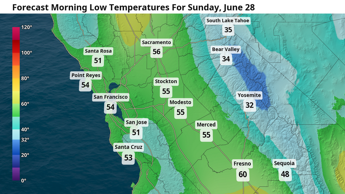
Elsewhere in the Sierra, temperatures at elevations greater than 7,000 feet Saturday will peak in the 50s before a drop into the 30s overnight Saturday into Sunday morning. There is even an off-chance for a few midnight snowflakes on Tahoe’s higher peaks.
Read more Davis just perfected NIMBY politics. Why the rest of the region should care | Opinion
As the front passes Friday and more cold air rushes on Saturday, winds will be gusty across the region upwards of 20 mph both Friday and Saturday afternoon. This is especially true in the Sierra and the coast, where wind gusts could reach around 40 mph at times. The National Weather Service in Reno, Nevada, has issued a lake wind advisory for Tahoe on Friday between 11 a.m. and 2 a.m. the following morning — and is likely to extend this advisory through much of the weekend as waves could reach several feet.
As our trough of cooler air exits early next week, it will leave a lingering north wind in place that will likely pose an elevated risk for wildfires across much of California and the western United States. We will continue to monitor this potential into next week.
Your forecast today
Sacramento and Modesto: Thursday will be similar to the past several days with sunny skies and warm temps, but already the cool air is starting to slip in. As the cold front approaches, it will boost the Delta breeze this evening and keep high temps only in the upper 80s. Folsom and areas further east and north of Sacramento will just barely scratch the 90s. Don’t be surprised to see a few clouds approaching close to sunset today. Those clouds truly arrive on Friday morning with even a few raindrops falling on the local radar (although you are unlikely to encounter these yourself). High temps Friday in the mid-80s with some occasional passing clouds and a nice westerly breeze gusting to 20 mph.
Fresno: Temps will certainly take a tumble over the next few days for Fresno, but still remain a bit warmer compared to elsewhere in the Central Valley. High temps this Thursday will be a touch cooler in the mid-90s as the low pressure trough approaches. The real cooldown arrives Friday with a high of 90 degrees followed by a further drop into the mid-80s Saturday. Winds will gust occasionally to 20 mph every afternoon from today through the weekend, especially in open areas facing west.
Read more Davis just perfected NIMBY politics. Why the rest of the region should care | Opinion