 By admin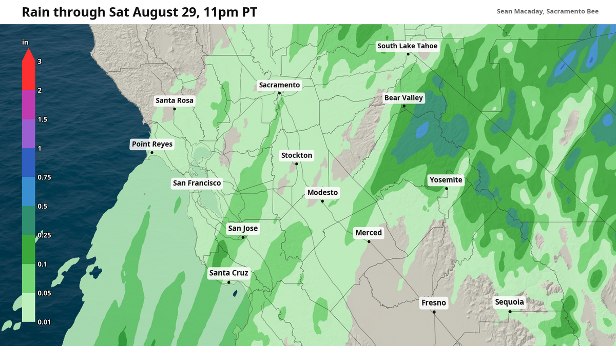
As summer draws to a close, the unending sunshine and heat will soon begin to fade. That’s not to say there aren’t sweltering hot and sunny days ahead this year — there will be plenty still over the next month — but these days are numbered.
Read more California NAACP, Equality California, SF Dems oppose Prop. 40’s billionaire tax
Central California is set for an early peek of what can be expected in the coming months and into winter: rain showers.
As of midday Thursday, rain showers were beginning to envelop the Central Coast from San Luis Obispo north through Big Sur, potentially offering some relief to the raging Big Timber Fire.
These showers will continue to push north and inland into Friday, with light showers expected across the Bay Area and in the Sierra.
For the Central Valley, while the radar might say rain as soon as early Thursday afternoon, conditions remain too dry for raindrops to reach the ground intact. The result will be virga — streaks of evaporating raindrops — across the valley from Sacramento south to Fresno Thursday afternoon that will cap high temps in the mid- to upper 90s.
While there is an off-chance for accumulating rain Thursday in the Central Valley, any such measurable rain is far more likely Friday as the atmosphere continues to moisten.
Most showers will be weak, with a few sparse and weaker thunderstorms possible at elevation in the Sierra. Thanks to the widespread nature of these showers, the wildfire threat remains modest. Rainfall accumulations in the mountains could reach up to a quarter of an inch in portions of the Sierra, with isolated spots pushing up to a tenth of an inch in the Central Valley. Most areas between Sacramento and Fresno can expect less.
Read more Pick the Preps: Folsom, Oak Ridge, Grant play monstrous openers vs. state powers
Moisture of former Tropical Storm Iselle responsible
All of these late summer showers are in part brought on by a pool of tropical moisture leftover from the remains of Tropical Storm Iselle — which died Wednesday after absorbing the even smaller Tropical Storm Julio over the eastern Pacific Ocean earlier this week.
As lower pressure sets up across the Pacific Northwest this weekend, the resulting motion of the atmosphere across California is out of the south-southwest, conveying all of this tropical moisture straight towards the Golden State.
The result is a steady stream of weak and widespread showers reaching well inland through Friday and the early morning hours of Saturday. In a preview of the winter to come, this moisture does have some similarities with the more powerful atmospheric rivers that will be possible in the coming months thanks to El Niño — although the weekend’s weather is far weaker and more tame.
Rain ushers in cooler temps for Sacramento Valley
These showers will work to cool the atmosphere, but the majority of the cooler temps arrive thanks to lower atmospheric pressure to the north between Oregon and Washington.
On Friday, high temperatures will quickly fall into the 80s for Sacramento and the Delta region south to Merced, with the low 90s possible for Fresno and areas further south.
These temperatures will continue to tumble through the weekend as skies clear, with highs in the low 80s for Sacramento, Stockton and Modesto. Some spots between the Delta region and inland Bay Area will only rise into the 70s Sunday despite a sunny forecast.
Read more A museum visit moves Alex Padilla, and sheds light on him skipping the governor’s race | Opinion