 By admin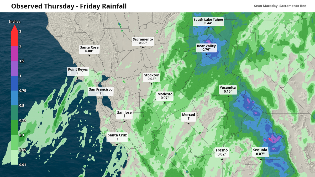
With two days of occasionally cloudy skies over Sacramento and the Central Valley ended the way most Valley residents suspected they would — a few spots on the windshield, some patches of wet pavement and not much else.
Read more Sacramento Bishop Jerry Lamb, whose vote to ordain gay man caused uproar, remembered
Up in the mountains, though, it was a different storm entirely.
Radar and rain gauge analysis compiled by The Bee shows the moisture that streamed over Northern California on Thursday and Friday — sliding in from what was left of Tropical Storm Iselle — dropped more than an inch of rain on the high Sierra peaks. In the upper Kings River east of Courtright Reservoir in Fresno County, the radar indicates total rainfall may have exceeded two inches, with another inch or more along the Sierra crest from Carson Pass south to Mammoth, and roughly half an inch around Lake Tahoe.
Sacramento Executive Airport, by contrast, officially recorded a trace on Friday and nothing at all on Thursday.
Meanwhile, Stockton, Modesto, and Fresno all recorded between 0.02 and 0.10 inches — not a lot, but notable given that this fell in the normally completely dry month of August. Not enough for a car wash, but enough to see nonetheless.
Tahoe and Reno got a taste of fall
The Lake Tahoe basin was the most-populated place to get a wetting rain. The South Lake Tahoe airport officially measured 0.28 inch, most of it Friday, when temperatures reached only 60 degrees.
Radar estimates put 0.49 inch over the city itself and 0.55 at Tahoe City. Truckee’s gauge stayed dry even as radar showed showers over the Martis Valley to produce some patchy fog there early Saturday.
Meanwhile, Reno recorded 0.12 inch Friday with a high of just 74, which is 16 degrees below normal.
Read more Pursuit of hit-and-run suspect in Lincoln ends in crash, police say
Rare for August
Any measurable rain is unusual for the last week of August. Sacramento’s normal rainfall for the entire month is 0.04 inch and Fresno’s average rounds to zero.
In the Sierra, August normals run 0.3 to 0.45 inch, meaning that some areas along the Sierra crest received two to three times a typical month’s rain over two days, and the Kings River high country roughly 10 times its August normal.
More rain possible over coming weeks
As the Super El Niño continues to strengthen and churn out new tropical storms and hurricanes in the eastern Pacific Ocean south of California, look for more similar plumes of tropical moisture to make their way northward toward the Golden State.
This may be a pattern that repeats itself, especially given cooler temperatures expected to continue sliding in over the next two weeks — with high temps comfortably in the 80s for much of the Central Valley. Even Fresno gets in on this, with several days of highs in the 80s later in the coming week.
The result of this cooler atmosphere will be one more prone to squeezing out tropical moisture rather than just evaporating it.
Read more El Dorado County sheriff’s correctional officer dies in Highway 50 crash