 By admin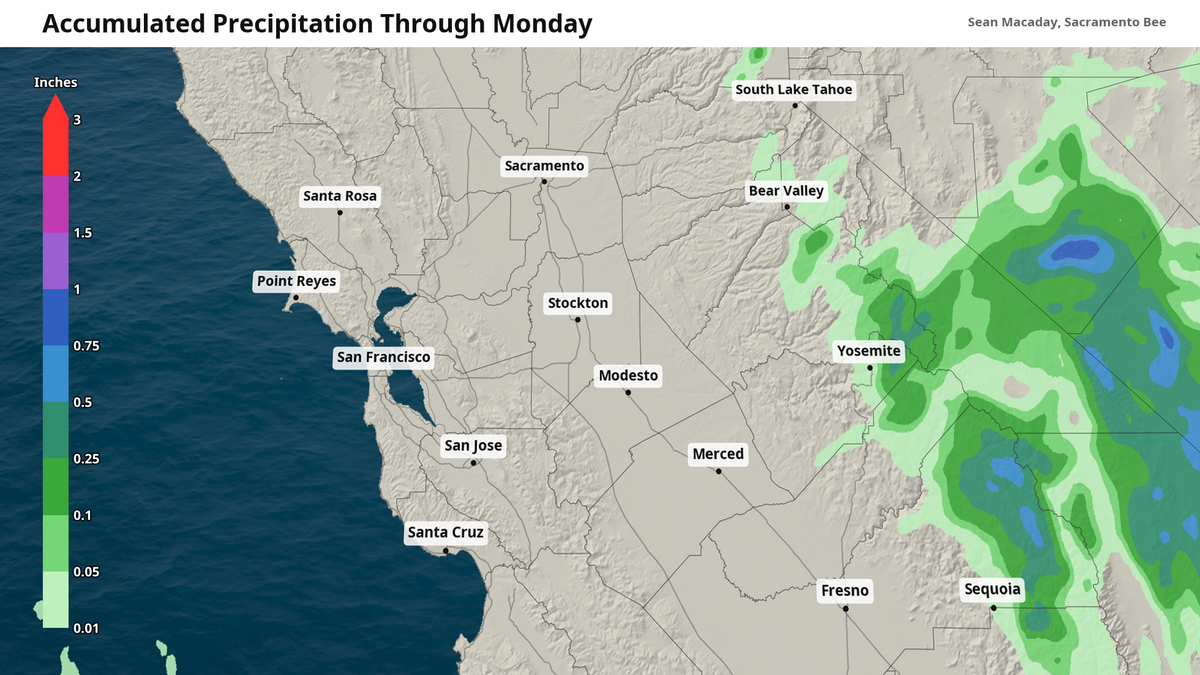
The clouds streaking across the sky Sunday and Monday are from a little metrological feature dipping into Southern California early this week: a cut-off low. And it will have implications across the Golden State — most directly a burst of showers and thunderstorms in the Sierra on Monday evening.
Read more Armed suspect killed in shootout with Placer deputies after all-night Iowa Hill manhunt
As the low pressure system takes hold over Los Angeles on Monday, it will force moisture-packed southerly winds directly from the ocean well inland and into the Sierra. Further north, as the moisture is squeezed out, streaky alto-cumulus and cirrus clouds will dot the sky across Central and Northern California throughout the day.
With nowhere to go put up as these southerly winds are forced into the ridge of the Sierra, the rising pockets of moisture will fall as rain along the mountaintops. Most of this rain is expected to be scattered and after 5 p.m.
Scattered Sierra showers in September are often accompanied by scattered thunderstorms, and that will be true this go around. Lightning, with the potential for spreading fires, will be possible late Monday if storms remain scattered enough.
Most of the rain is not expected to reach the ground below 4,000 feet. Higher up in the peaks, above 12,000 feet, some of this rain could come down as a few early season snowflakes. Showers will wrap up soon after midnight Monday, with some lingering in the Mono Lake area beyond the Sierra crest into Tuesday morning.
Temps begin to rebound Wednesday
After the cut-off low departs late Tuesday, the atmosphere will begin its rebound to equilibrium through the week, bringing temperatures back to average or even slightly above average to the end of the work week.
Monday and Tuesday will remain slightly below average, with high temperatures in the low to mid-80s for the majority of the Central Valley from Sacramento to Fresno.
Read more Placer woman found shot dead amid manhunt for armed suspect in remote Iowa Hill
On Wednesday, underneath a summer-like sun (although it will officially be fall), temperatures will push into the upper 80s and low 90s across most of the area, and continue to rise into a hot Thursday. A return of triple digits is not out of the question for the far southern San Joaquin Valley on Thursday. Sacramento will be firmly in the 90s.
The Delta region, Sacramento included, can rejoice in the Delta breeze being a consistent feature through the week, offering some reprieve from the stubborn summer afternoon heat.
Dome Fire in Yosemite National Park
The potential Sierra showers are unlikely to affect the fire burning in Yosemite National Park, most of which is burning below the elevations where rainfall is likely.
As of late Sunday, the Dome Fire was at 3,042 acres and 15% containment at the southern end of the park near Wawona. Intense Monday evening southerly winds — as showers and storms higher up in the mountains begin to form — will be conducive to pushing the fire further north towards the center of the park. Southerly winds gusting at 30 mph late Monday could pose challenges to containing the fire.
Smoke from the fire will continue to push north through Tuesday along the Sierra ridgeline, possibly reaching the South Lake Tahoe area by later Tuesday.
Read more Can I have beer, wine or booze in my CA car? Open container laws explained