 By admin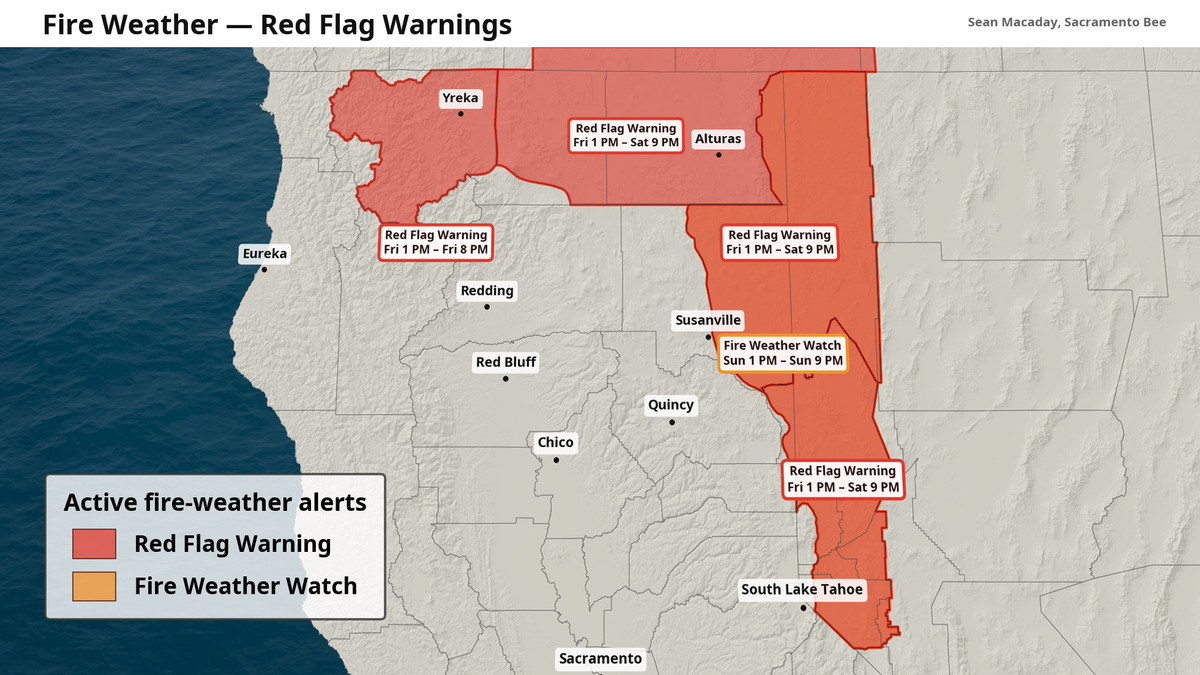
After a bout of clouds, and even a few scattered rain showers across the mountains earlier this week, temperatures have settled down to what we normally expect this time of year – unrestricted sunshine and heat.
Read more Experts warned of Venezuela’s earthquake risks for decades. Little done, they say
This is expected to carry into the weekend and into next week, but there are a few interesting wrinkles to unpack amid what is leftover from Tropical Storm Elida and ongoing wildfires across northern California.
Average-to-hot weekend, with minimized Delta breeze
This weekend will be another slightly above average stretch to enjoy the outdoors, with more sunshine to go around to add some extra heat.
High temperatures will reach into the low to mid-90s for all of Friday, Saturday, and Sunday for the southern Sacramento Valley, including the State Fair. However, unlike last week and weekend, this weekend will not benefit as much from that cooler evening Delta breeze.
The reason is rather fascinating; last week’s passing of Tropical Storm Elida to the west created a consistent stretch of southerly winds all along the coast. Those winds suppress the upward drag of cooler water from the deep ocean through Ekman transport or the Ekman Spiral. The result has been a noticeable rise in ocean temperatures by about six to eight degrees along the coast this past week, which has worked to weaken the marine layer that keeps the coast more foggy.
The side effect of this entire pattern has been a warmer Delta breeze carrying with it just a bit more humidity in the evening for Sacramento. If you have noticed it’s been warmer overnight lately, this is why. Sacramento low temps in the low 60s and a bit of extra humidity through next week are all lingering impacts of Tropical Storm Elida on our coastal environment.
The good news is that ocean temps are expected to cool again as the upwelling starts next week, so low temperatures could improve in a week’s time if all goes right.
Read more How sports, housing, transit developments are reshaping Sacramento’s Railyards
Fire risk for northern California
Further north, high temps won’t be all too different from what one would expect with 80s and 90s common all the way to Oregon. However, a combination of very low humidity and an afternoon breeze has increased the risk for wildfire spread. For that reason, the National Weather Service has issued a Red Flag Warning for parts of northern California, northwest Nevada, and the Lake Tahoe area for Friday and Saturday afternoons, with a Fire Weather Watch Sunday afternoon that is likely to be upgraded to the same Red Flag Warning.
Fires can spread rapidly in these conditions, so be sure to have a way to access emergency information this weekend. Some fires are still ongoing across northern California as of late Thursday.
Western heat wave looms into August
What is surely not great news for the risk of wildfires across the western U.S. is looming warmer temperatures into the end of July and early August. In a week’s time, high pressure in the upper levels of the atmosphere is expected to accumulate across the western U.S. in a “heat dome”. This will likely push high temps towards or above 100 degrees for an extended stretch. The one caveat is, if the center of the heat dome is positioned directly to our west, it may bring about another strong plume of the monsoon. In which case, extra moisture and potentially even another bout of rain could keep temps from their worst potential. We will continue to track this feature.
As of Thursday, July 23, the Climate Prediction Center is expecting a large swath of above average temperatures across California through August 6.
And this is worth a quick note, if you have any plans next weekend on August 1st, such as heading to the California State Fair or anywhere outdoors, than this current weekend is almost surely going to be the cooler one for getting outdoors. A nice tidbit as you formulate your plans to wrap up July.
Read more Sacramento City Unified faces new county payment oversight amid budget crisis