 By admin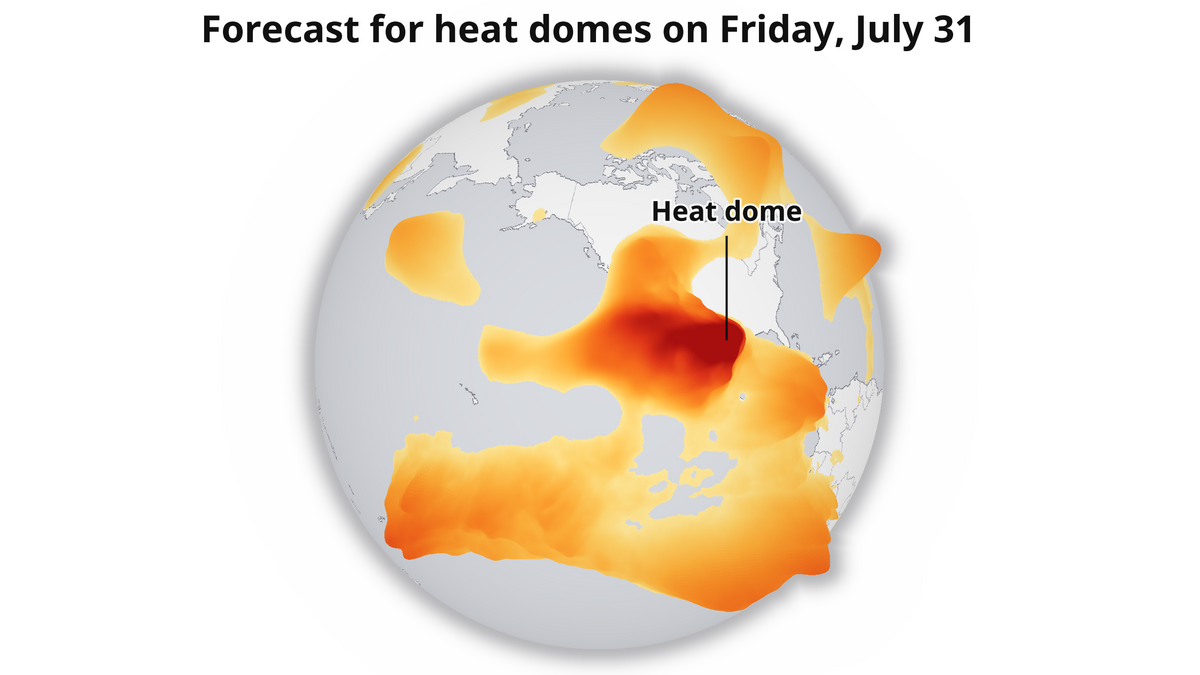
Another heat wave is on California’s doorstep, and this one will have the backing of the largest heat dome on Earth when it arrives.
Read more The hottest weekend of summer is here. Here’s how high the heat will climb
Heat domes are collections of higher-pressure and intrinsically warmer air stretching through to the upper atmosphere. From there, the weight and heat of the atmosphere pushes toward the ground, leading to clear skies that bake the surface beneath.
Heat domes across the Southwest are not uncommon, but ones of this magnitude are more of a once-a-summer occurrence.
That high magnitude will be especially pronounced in Southern California, where unusual humidity – driven by this year’s super El Niño – combined with the center of the heat dome being directly overhead, will push inland feels-like temperatures well above 100 degrees in some instances. A string of heat advisories, extreme heat warnings and heat watches are out for the southern half of the state through the weekend. Temperatures will be unusually high and potentially dangerous.
The largest heat dome on Earth will be right over the southwestern US this Friday.
Partially strengthened by Hurricane #Genevieve, temps will soar into the triple digits for an extended stretch across central California into next week. #cawx pic.twitter.com/7m6MONON80
— Sean Macaday (@MacadayWX) July 30, 2026
Further north, much of the Central Valley can expect sweltering heat through the weekend. Triple-digit high temps will cover the entire Central Valley, with highs approaching 110 degrees near Bakersfield in the south and Redding in the north. Temperatures in Fresno are expected to exceed 105 degrees this weekend.
Sacramento, Stockton and Modesto, closer to the cooling Delta, will not fair much better. High temps will rise above 100 degrees each day into early next week, with the heat dome working to snuff out the Delta breeze.
Locations along the coast will fair better, but can still be expected to experience unusual heat. Parts of San Francisco will climb into the 80s and San Jose in the 90s.
Humidity will gradually fall through the weekend as the air dries out across the region. Wildfires will be a growing risk day by day as afternoon relative humidity values fall into the single digits and teens across interior California.
Hurricane Genevieve to boost temperatures
Earlier this week, Hurricane Genevieve in the east Pacific Ocean exploded into a Category 5 hurricane from a weaker tropical storm in just over a day.
That process of rapid intensification will increase California temperatures a touch this weekend.
Read more California bill targeting monopolies under attack from business, science groups
As the hurricane rapidly grew in strength, drawing moisture from the ocean and rapidly converting that to clouds as the air rose, it released a tremendous amount of heat. And tremendous might be an understatement — at one point it was producing the same amount of energy as a 10-megaton atomic bomb going off every 20 minutes.
That heat doesn’t just disappear. Some of it turns into the kinetic energy that is the hurricane’s strong winds. But a larger chunk of the heat rises into the upper atmosphere, flows northward towards the North Pole and runs into our heat dome. That just makes the heat dome stronger.
It’s likely responsible for few additional degrees of temperature here and there, but when you have 100-degree heat across a large stretch of the state, that few degrees can be the difference between enjoying the outdoors with a bottle of water or just deciding to stay inside.
For NorCal, heat will linger into next week
Partially aided by Genevieve’s forecast track further west into the ocean, our heat dome will linger for Northern California well into next week.
That means you can expect the hot temps to stick around for places like Sacramento, Fresno, Redding and even the Bay Area (which will admittedly be cooler). Southern California will be able to cool off as the heat dome moves further away.
The orientation of this heat dome next week does pose a challenge for fire management across Northern California. Centered just west of the north state next week, the high pressure will force a northerly breeze that will work to dry out the region even more. With relative humidity in the single digits and teens across interior California next week, , wildfire risks will be high.
A large heat dome is set to overtake the western U.S. this weekend. And while it does attempt to back off a bit, it will reamerge mid-next week and keep temps in central and especially northern California hot even while SoCal cools down. #cawx pic.twitter.com/l0BYaPvAPv
— Sean Macaday (@MacadayWX) July 30, 2026
That north breeze could also carry some wildfire smoke from Oregon, which would lead to a dip in air quality across the Central Valley.
For Sacramento and Modesto, the north breeze will diminish the Delta breeze, and keep high temps in the triple digits for an extended stretch.
Read more A’s, Giants both likely sellers at next week’s trade deadline. Who could leave?