 By admin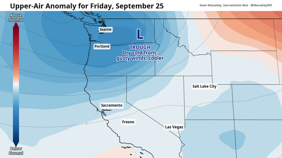
Welcome to fall! The days are growing shorter, the temperatures cooler and the air just a touch more crisp. And this weekend, after a few days with above-average temps, the weather will agree with the new season.
Read more Longtime Sacramento official announces retirement, putting city leadership in flux
High temps this weekend will grow cooler with each passing day. By Sunday, high temps are in the 70s across much of the Sacramento Valley, and in the mid-80s across the San Joaquin Valley.
This cool down is thanks to a trough swinging in out of the northwest. Lower pressure through the upper atmosphere is pushing inland and diving south, sweeping in cooler temperatures and passing clouds across the Golden State between Friday and Sunday. As the trough passes, winds out of the west will be a continual feature. A boosted Delta breeze will keep the middle Central Valley from Sacramento to Modesto on the cooler side of high temps through Monday.
Red flag warning for Reno
For the other side of the Sierra, these westerly winds pose a problem: Dry air and strong winds are a recipe for fire.
A red flag warning has been issued for Reno, far western Nevada, and Alpine and Mono counties Friday afternoon and evening ahead of wind gusts up to 40 mph. Low relative humidity will mean that any fires that do spark will easily spread east.
Fire risks will also be elevated across the rest of Northern California, although the bulk of the problematic winds will be across the Sierra peaks and into the Lassen area.
Read more Your guide to Prop. 38, an $8.4 billion bond measure for immunology research
Hurricane Polo will influence weather early next week
As of late Thursday, Polo was again a Category 5 major hurricane after weakening slightly Wednesday.
Hurricane Polo is poised to be the first hurricane of the year to make landfall when it hits Baja California early next week, when the weakening but still powerful storm will sweep ashore north of Cabo. As the storm continues to race north, it is poised to deliver drenching showers mid-week across portions of New Mexico and western Texas as its moisture gets caught up in the trough passing now across California.
As Polo is absorbed by the upper atmosphere, it will amplify the pattern across the continental United States. Given the enormous energy packed away in Category 5 hurricanes, this could mean a prolonged cooler and drier period early next week, or the complete opposite if Polo veers too far east. Major hurricanes are a wrench in the system when they become absorbed in the jet stream, as Polo will be early next week, so how exactly this plays out will be closely watched.
This story was originally published September 25, 2026 at 5:00 AM with the headline “A California cooldown with Sierra fire risks — this weekend’s temps and wind.”
Read more Cristiano Ronaldo Endures Nightmare First Game Under New Portugal Manager