 By admin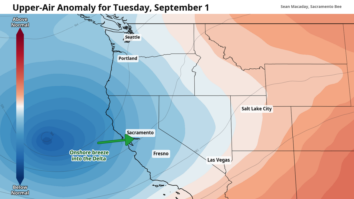
Get ready: The most comfy temperatures in months are on the doorstep of much of northern and central California.
Read more Jenny Rodriquez finds the ‘win-win’ for Sacramento small businesses, professionals
Between Monday and Tuesday, a trough of lower pressure air through the upper atmosphere will unlock an early taste of fall across the Central Valley, Bay Area and western U.S.
A trough refers to this area of lower pressure dipping down from Canada, creating a valley shape on atmospheric height maps where the low pressure resides. These features are a normal part of U.S. weather, and typically come with stretches of cooler, cloudier, and sometimes rainy weather.
What is not as normal about this trough is its strength. As the central U.S. is stuck under a stubborn heat dome that will not move, our western U.S. trough is forced to dig in and develop further. In other words, the atmosphere over California is shifting into another gear to try and cool things down.
This change will be tangible. Between Monday and Tuesday, high temps across the Central Valley will fall from the low 80s near Sacramento and Modesto on Monday well into the 70s by Tuesday afternoon. The drop is even more stark in the San Joaquin Valley, where Fresno high temps will tumble from the 90s to the low 80s.
This cool down will be a nice relief across the Central Valley, when high temps this time of year are typically still in the 90s, but it is even more welcome for Southern California. Last week, portions of the Los Angeles area were experiencing 90 degree temperatures and downright tropical humidity, with dew point values even higher than the southeastern U.S.
This pattern change will offer some relief to Southern California. Los Angeles high temps will dip about ten degrees into the 80s this week. And while ocean temperatures along the coast will remain warmer than average through the coming months — fueling more abnormally hot and humid days — the overall atmospheric pattern will help cool things down.
Worth noting: High temps this week will be cooler in Fresno than in L.A. That doesn’t happen often this time of year, and it’s a testament to the autumnal nature of our weather pattern this week.
Delta breeze will push marine layer fog to Sacramento Tuesday morning
For Sacramento, Modesto and Delta region residents, the most autumnal testament comes in the form of a cloudy — and perhaps foggy — morning Tuesday and the marine layer slides inland.
Read more A serious cooldown to end summer — how low will temps slide across California?
With low pressure strengthening off the coast, winds out of the southwest will be forced into the Bay Area and through the Delta. The result is a boosted Delta breeze Monday evening and overnight. Winds could gust up to 25 mph near Sacramento and the greater Delta region Monday evening, and continue flowing through the night.
By the morning, this boosted breeze will have brought patches of marine layer clouds and fog inland. Much of this will burn off by the afternoon, but if you are craving a nice morning run or walk that feels like an ocean breeze, Tuesday morning is your window.
Tropical storms, hurricanes will continue to point moisture at California
The eastern Pacific hurricane factory is full steam ahead. Thanks to well above average ocean temperatures due to the Super El Niño, tropical storms and hurricanes south of California are forming at breakneck speed.
On Sunday night, Hurricane Karina rapidly intensified into a monster Category 4 hurricane with max winds of 145 mph. Karina will stay away from land — spinning out its days in the open ocean — but some heavy surf could arrive to the shores of California later this week.
Future storms may bring more weather to the Golden State. With the atmospheric trough setting in over California and the western U.S., any tropical storm or hurricane that veers to close could find itself under the trough’s pull, changing direction and charging towards the coast of Southern California.
This is, to put it plainly, very unlikely. However, a few runs of the American GFS model over the weekend that showed this exact scenario, and a flurry of social media reactions and posts claimed that a hurricane could hit California next week. These posts do not mention that nearly every other weather model does not have this output.
So while future hurricanes south of California will be worth keeping an eye on, we are nowhere near the time for caution yet. What is more likely is that some of the tropical moisture bundled away in these storms finds itself spread across the California later this week and next — as was the case last week when moisture leftover from Tropical Storm Iselle produced rain across Central California on Thursday and Friday.
Read more Sacramento e-bike back-to-school guide: Rules, safety tips and resources