 By admin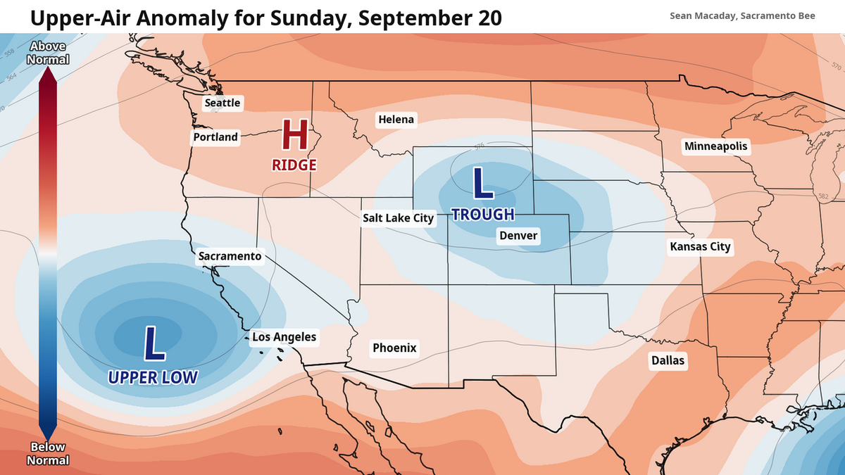
September, despite a few days peaking into the triple digits, has been pleasantly mild so far across Central California, and that pattern is not going anywhere anytime soon.
Read more Sacramento sheriff’s deputies shoot carjacking suspect after Arden Arcade pursuit
Thanks to a series of upper-level low-pressure systems — kinks in the jet stream that bring down cooler temperatures from the north — California temperatures have remained below average so far this season.
And wouldn’t you know it — it’s the exact same thing again this weekend, particularly for Sunday and Monday. Before then, Friday and Saturday temperatures will slowly rise into the upper 80s and low 90s, fairly average temps for mid-September, throughout the Central Valley under sunny skies.
Then on Sunday, the upper level low arrives from the Pacific Ocean. This will decrease temperatures across the entirety of Central and Northern California, brining partly cloudy skies to the Central Valley and even some briefly overcast conditions to areas north of Sacramento.
High temperatures during this time will quickly dip into upper 70s for the Sacramento area at large, and the low 80s for the rest of the Central Valley.
And do not expect skies to change much into next week — when the weather is set to do something once, it is often set to do it again. More of these passing lows are possible through the rest of the month with cooler temperatures and the occasional cloud abound. And with the autumn equinox set for Tuesday at 5:05 p.m., it may start to feel about right for this time of year.
Read more The Aerospace Museum of California has over 35 airplanes. Here’s how they get cleaned
Meanwhile, El Niño is nearing new territory
Despite calm weather across the Golden state, all eyes are still watching the east Pacific, where El Niño continues to strengthen and will begin to influence weather into the coming winter.
As of late last week, the sea surface temperature anomaly — how far above normal temperatures are compared to average — of the Niño 3.4 region was 2.9 degrees Celsius or 5.2 degrees Fahrenheit. Even over the past week, the latest estimates out of this region are now very close to 3 degrees Celsius.
The previous strongest El Niño on record using the Oceanic Niño Index was 2.75 degrees Celsius in 2015-2016. Older El Niño events, such as the 1877–1878 event, could have perhaps been slightly stronger. Still, current forecasts push this anomaly rising towards 4 degrees Celsius over the next few months, in part fueled by warmer waters thanks to climate change.
Early climate models are already pointing towards above average rainfall this winter season. As El Niño grows stronger, we will have a better idea of what to expect on a month-to-month basis.
Read more Rodent droppings, motor oil: What Sacramento County food inspectors found this week