 By admin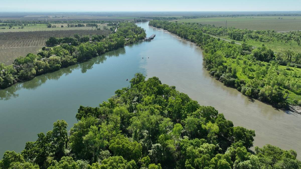
The road into Dos Rios Norte crosses a bridge. It’s a small one-lane hop over the creek, and then the land opens up.
Read more Update: Moss Landing battery plant fire knocked down, company says
This is the part Bryce Lundberg mentions first. Not the shear size, or the price, or the wildlife, not even the spring floodwaters. The bridge. “You go across that bridge, and you go out there and say, ‘wow,’” he said. “It’s like you’re in a different world.”
On the other side is 1,600 acres of forest-ringed rice field, set at the confluence of the Feather River and Sacramento River, with Butte Creek sliding in from the north. Rice is a crop that needs flooding, and the Lundbergs — of the locally owned Lundberg Family Farm brand — have grown it here for generations. Engines roar in all directions, powering pumps along the rivers that pull water into the field on a hot August day.
Walk the field this time of year, and barren patches are visible — spots where nothing has grown and the rice has died or gone missing. These spots are still damp, even when the rest of the Central Valley is drying up. The rivers took these low spots for themselves in the spring, and did not give them back in time to plant.
The land is the lowest point in the Sutter Bypass, the flood channel built a century ago to carry excess water south. The people restoring it say it is the wettest place in the Sacramento Valley. Cameras on the property have recorded the water rising 20 feet. Walk through the peripheral forest, and gnarly bundles of sticks and grass hang from the trees above — lifted there from floods months earlier.
The Dos Rios Norte property is where three rivers, a flood bypass and a changing approach to flood control converge. For generations, the Lundberg family grew its rice, even as floods repeatedly made the land difficult to plant. After selling the property to restoration nonprofit River Partners, the land is becoming something else: a working floodplain designed to hold water and provide habitat — a test of whether giving rivers more room can make the Central Valley safer for the big storms the future will bring.
Lundberg’s grandfather came to California in 1937, leaving behind the Midwest where the rain had quit for years and the plowed topsoil had blown away. The Dust Bowl was a drought, but it was also a farming practice, and the family carried the lesson west: Leave the land better than you found it. When they bought Dos Rios Norte two decades ago, they started converting it to organic on the first day.
And yet, some years it doesn’t get farmed. In 2017, when the Oroville Dam’s spillway came apart upstream, the fields sat beneath the Feather River for months, and the Lundbergs farmed nothing on the land. “It’s a challenging piece of property,” Lundberg said. “It’s inside the levees. The Feather River, the Sac River and Butte Creek can keep that farm underwater.”
So in 2023 the family did something farmers rarely do with productive ground. They sold it to River Partners and stayed on as tenants. “It became apparent to us that we didn’t need to own it in order to farm it,” Lundberg said. He calls it a win-win: The sale freed money to move other ground to organic, and it put the wettest field in the valley in the hands of people who want it wetter.
Lundberg doesn’t expect to plant rice on the property this spring either.
“It will likely be underwater, right?”
He expects the Oroville, Shasta and New Bullards Bar reservoirs will hold water late and release it late, and that the field will stay a lake into well into planing season.
“That’s not worst-case scenario,” he said. “There’s going to be seasons where the land is going to be underwater longer. But I do think it’s an opportunity.”
El Niño could bring the floods
Thousands of miles to the south, the strongest El Niño ever measured is building in the tropical Pacific. The swath of warm equatorial water has already warmed to the 2015 record with months of strengthening still ahead. In an update last week, the National Oceanographic and Atmospheric Administration put the odds of the El Niño maintaining record strength through the end of the year at 75%.
That could mean more water for Dos Rios Norte.
“For strong and very strong events, El Niño’s relationship with California precipitation extends significantly farther to the north,” said Daniel Swain, a climate scientist with the California Institute of Water Resources, “and does include the Bay Area, the Sacramento region and most of the Sierra Nevada.”
In The Sacramento Bee’s climate model simulations built with dozens of synthetic super El Niños, the strongest events line up with the wettest California winters statewide.
Long-range climatic models for this winter from U.S. and Canadian weather agencies agree. Averaged across five of them, December and January come in 40% to 65% wetter than normal statewide, and none show a below-normal month for any California city. Sacramento averages about 3.5 inches of rain in each of those months; NOAA’s model adds 2 to 5 inches to both.
Boosted by warmer temperatures from both El Niño and climate change, the upcoming rain will be warmer. That is the second half of what a super El Niño means for this valley. Warmer storms hold more moisture, and push the snow line up the mountains, so precipitation that should be saved as snowpack runs off as rain. California saw this pattern earlier this year: near-average precipitation in many places alongside an April snowpack that was the second-lowest on record — 18% of normal statewide and 6% in the northern Sierra. Meanwhile, state reservoirs remain at healthy levels. A wet, warm winter on these slopes is a winter of high, fast rivers.
The strong El Niños that have delivered were among the wettest years on record. In February 1998, three consecutive atmospheric rivers brought record precipitation to nearly all of California, and towns such as Willows were flooded for days. The winter before, in January 1997, the Feather and Yuba tore through Yuba County. In 1955, a Christmas Eve levee failure at Shanghai Bend on the Feather River inundated 90% of Yuba City and killed 38.
The possibility exists for worse floods. The Great Flood of 1862 is remembered for how it inspired Sacramento to elevate its streets. And a hypothetical worst-case scenario exists in ARkStorm 2.0, a study co-led by Swain with the U.S. Geological Survey and the state Department of Water Resources that modeled the storm sequences capable of producing California’s most extreme four-week rainfall totals. Of eight, seven came during moderate to very strong El Niños. The one chosen for the study used a sea surface temperature close to what models now project for this winter. The same work found that climate change has already doubled the likelihood of a catastrophic California flood.
Another thing is different this time: California is not entering this El Niño from a deep drought — the reservoirs are in good shape. In a dry state that is good news. In a state bracing for a wet winter, it means less room to catch what comes.
The data points to more rain. The question is how to control it.
Where the water goes
Mike Davis stands at the point.
To his right the Sacramento River comes down brown and heavy from the north. To his left the Feather arrives from the Sierra in lighter hues of blue. They meet at his feet, and for a stretch the two rivers run side by side before they blend in a series of eddies. A small marina sits across the water. Farther down, the levee that restrains the rivers is a low line of trees into the horizon.
Davis is a fish biologist who directs the Dos Rios Norte project for River Partners. He has worked on rivers his whole career. “I have never worked at a place like this,” he said, “at the confluence of three rivers and three distinct runs of Chinook salmon.”
He is also standing on what River Partners intends to make the single most important piece of land for conveying floodwater in the Sacramento Valley’s flood system — the place the system counts on when the rivers are at their highest.
To see why, follow the water.
When a big storm hits the northern Sierra, the Feather River’s runoff lands in Lake Oroville, behind the nation’s tallest dam, and the Yuba’s lands in New Bullards Bar. Their operators, the state Department of Water Resources and the Yuba Water Agency, release what the dams cannot hold. The two rivers join at Marysville and Yuba City, in a system built to pass 300,000 cubic feet per second. Below that, the Feather runs south to Dos Rios Norte where it meets the Sacramento River.
Meanwhile, the Sutter Bypass is carrying its own load. Water from Butte Creek is funneled in off the Tisdale Weir 20 miles to the north along a levee-lined channel to the same place. The Feather, the Sacramento and the bypass converge on one point — Dos Rios Norte.
When the river reaches 32 feet in elevation at this location, water spills over the Fremont Weir, a nearly two mile-long concrete barrier, into the Yolo Bypass. This 59,000-acre floodway carries the river’s excess past the state capital. The Sacramento Weir north of West Sacramento is the system’s last release valve. Its 48 manual gates have been opened only 23 times since 1916, most recently in 2017. An expansion that would add a backup, a roughly 1,500-foot passive spillway, was supposed to be done this December, but a sinking concrete abutment pushed the completion date to winter 2027. El Niño’s extra water could arrive before then.
That is the plumbing. The way the state wants to run it is changing.
After the 1997 flood, the operators of Oroville and Bullards Bar began coordinating their releases, moving toward what is called forecast-informed reservoir operations: releasing water earlier and in larger amounts ahead of large rain events, so the dams have room when its needed.
Earlier, bigger releases need somewhere to go. Davis said the operators of Oroville have asked River Partners whether the restoration at Dos Rios Norte could allow the dam to send more water down the Feather. “The answer is yes,” he said.
River Partners cannot impede the flow of the Sutter Bypass. The restoration is designed around that constraint, with the flood function of the bypass held fixed. What the design can do is give the water more room. “We are looking for places the river can hold more water,” Davis said.
Dos Rios Norte has flooded the past three springs. The bet the whole flood control system is making on a super El Niño — to be able to carefully manage and control the flow of water without getting stuck — runs across this patchy, difficult-to-farm ground.
Let it flood like it used too — hundreds of years ago
Jennifer Norris has spent a career in conservation, and she describes the old way of thinking in one sentence: levee the river and protect ourselves from it “by building a wall between us and the river.”
Read more Week in photos: Plane wash + 9/11 + new supermarket + rodeo
Norris directs the California Wildlife Conservation Board, the state agency that approved a $22.6 million grant that helped River Partners purchase Dos Rios Norte. She lives near the American River, and she has watched the wall get reinforced in her own neighborhood. After the 1986 flood, she said, “they just built the levee stronger and higher, and now they’re like, ‘Hold on, let’s actually think about making the river more functional.’” Along the river now, wetland habitat is being created to act as what she calls a sponge.
The wall has never been enough. The Sacramento region is the U.S. metropolitan area with the highest flood risk, beating out New Orleans after 2024 post-Katrina levee repairs, according to Gregory Treible with the U.S. Army Corps of Engineers. Across the Central Valley, 1.3 million people live and work on the floodplain, with $223 billion in buildings and a $17 billion farm economy behind the levees. By 2072, the state estimates, climate change could push peak flood flows as much as five times higher than today.
The valley was made for this. Before there were levees, there were 4 million acres of wetland here, an inland marsh that took the Sierra’s runoff every spring. Five percent of it now remains.
In December 1861 it began to rain, and it rained for 43 days straight. By January, the Central Valley was a lake 300 miles long and 20 miles wide; downtown Sacramento stood under 10 feet of water, and the state went bankrupt. That flood was not a freak incident. Sediment cores from Little Packer Lake, in the Sacramento River floodplain, record floods of the same magnitude about every century or two going back a thousand years.
People lived through these historic floods. Dos Rios Norte used to be a village. The Shingle Springs Band of Miwok Indians count the site among their ancestral homelands. A 1916 federal census recorded Miwok and Nisenan people living along the Sacramento River at this location as the “Sacramento-Verona Band of Homeless Indians.” Tribe members tell stories from when their ancestors lived on this land. In 2020, the tribe reacquired land at Verona across the Feather River from Dos Rios Norte, which the federal government took into trust last year.
River Partners has opened Dos Rios Norte to the tribe for ceremonies and foraging, and says shared management will be central to the property’s future.
Nature-based solutions for holding damaging floods
On Dec. 16, 2022, the Central Valley Flood Protection Board adopted a . Eleven days later, the atmospheric rivers began. In 24 days, 34 trillion gallons of water fell on California; 21 river forecast points in the valley reached flood stage, and the governor declared an emergency on Jan. 4.
The plan on the board’s desk called for a move “away from practices that constrain nature and towards strategies that work with nature.” Levee setbacks, floodplain storage, land bought outright or under easement and returned to habitat are now formal categories of flood infrastructure. More than $25 billion in spending is planned over the next 30 years to prepare against a potential catastrophic flood the state estimates could cause $1 trillion in damage.
The money has followed. The Wildlife Conservation Board has spent $278 million over five years on restoration and land acquisition across the Central Valley. In November 2024 voters passed a $10 billion climate bond. “This is an investment by the state on their behalf,” Norris said. “If they voted for the climate bond, these are the kinds of projects that that allows.”
She calls what happens at a place like Dos Rios Norte “a win-win-win:” less flooding, more groundwater recharge, better habitat. And she has a term, “pinch point,” for where it sits in the system.
Norris also has a comparison, and she offers it as a citizen as much as an official.
“We’ve made investments in forest health projects too,” she said, “and where we have these big fires, we see the fire slow down when it gets to the place where the forest work has happened. And I think we’re going to see similar things in places where we’ve done these multi-benefit projects.”
Californians have watched one nature-based solution get tested by a disaster. This winter could be the water version.
“We’re going to see those benefits — less flooding, more groundwater recharge, healthier rivers overall, and I think safer communities,” Norris said. “It’s a prediction. But I’m glad that we’ve made the investments we have.”
The prediction is not without evidence. At Hamilton City, on the Sacramento north of Chico, residents evacuated six times over the past 30 years before the Army Corps of Engineers finished a 6.8-mile setback levee in 2017 — the first project in the corps’ history to pair flood protection with ecosystem restoration. River Partners planted roughly 1,500 acres of floodplain between it and the river here. When the river rose in February 2023, the new floodplain held as much as five feet of water, perhaps 4,000 acre-feet at the peak. The young trees came through fine. This past February it absorbed floodwater again.
At Dos Rios State Park near Modesto, where the Tuolumne meets the San Joaquin, River Partners spent a decade turning farmland back into floodplain. In 2024 it became California’s first new state park in nearly 15 years. During large dam releases, it can absorb up to 10,000 acre-feet of water, and it returns about 7,000 acre-feet a year to the aquifer and the river.
River Partners is candid about the limits. Dos Rios Norte, on its own, is not going to lower a flood substantially. The property already floods; what it lacks are the features of a working floodplain that can control flow. Davis put it plainly: The benefit is in the greater system — a bypass that can carry more, reservoirs that can release earlier, dozens of sites up and down both valleys, including Dos Rios Norte, where the river has been given room.
And as River Partners begins work at Dos Rios Norte, the property is vulnerable this winter for the same reason it matters. Restoration here means grading the interior, cutting channels for fish, seeding native vegetation and then irrigating and tending it for three years in what they call the establishment period before walking away. A bad flood in those three years can undo a season’s work. Invasive weeds already cover much of the ground. The target for completion is 2032.
Perhaps the biggest benefactor — salmon
What the restoration is for, Davis will tell you, is fish.
Chinook salmon reach this confluence from three directions. Biologists sampling the Butte Sink and Sutter Bypass have caught juveniles of all four Central Valley runs — spring, fall, late-fall and winter — in a single season. Butte Creek holds one of only three fully wild spring-run populations left in the valley, fish with no hatchery in their lineage. And when they leave the creek most of them do not hurry. Tagging studies found that recaptured juveniles were far more likely to linger and grow on the floodplain, around 72 days, than to pass straight through.
Davis is measuring it. River Partners has strung an acoustic telemetry array through the site, listening for tagged fish as they move between the rivers and the bypass. The restoration plan will excavate channels into the interior so that fish can find their way onto the field when it floods and back out it without stranding when the water drops. Over time the rice will give way to oaks, willows and native grassland. “Eventually, this will cease being a rice farm and become a native habitat,” Davis said.
The valley is already testing the theory. On July 16 anglers lined the Feather at Oroville for the first full recreational chinook season on the Sacramento River system in four years. After three years in which California’s salmon fishery was shut down almost entirely, the commercial fleet returned to the Pacific this year.
The state’s fish and wildlife department credited wet years that refilled the rivers, habitat work that gave returning fish places to spawn and rear, and increased hatchery production. Just downstream of Dos Rios Norte, the Fremont Weir spilled into the Yolo Bypass on Dec. 29 with its new fish notch in place for the first time.
The field already has tenants beyond salmon. Giant garter snakes, yellow-billed cuckoos and willow flycatchers live along the forested edges. Rare native plants hang on in scattered patches. Davis even recently found bear scat.
Where the water stays
The hum of the engines pumping water onto the field echoes across the field. Within a few years they will be gone. After the establishment period ends, so does the irrigation. “We never use this water again,” Davis said.
The water rights that come with Dos Rios Norte are among the oldest in California. River Partners intends to give them back. “In the future,” said Sean Murphy, the organization’s spokesperson, “we would like to dedicate these water rights to the river.”
Lundberg will keep farming what he can, for as long as it makes sense. “Part of climate change is extremes,” he said. “The very wet and the very dry, and this El Niño that we’re looking at is the very wet. And then we’re going to have the very dry. The extremes are going to be more the norm.”
For Davis, it is all about the scale. “I never thought I would work on something this big,” he said. He imagines the visitors who will someday cross the bridge and see forest reaching the water on each side. “This could be an opportunity to see how the valley truly used to be.”
Some winter soon, and maybe this upcoming one, the Feather will come up behind late December storms the way it did last year, and the Sacramento will come up to meet it, and the Sutter Bypass will run bank to bank. The water will spread across the low ground at the confluence, over the rice stubble and the bare patches that never dried, and it will stand there for weeks. Twenty feet or more of it. This time, that will be the point.
Read more El Niño could usher Central Valley floods. One strategy: let it flood like it used to