 By admin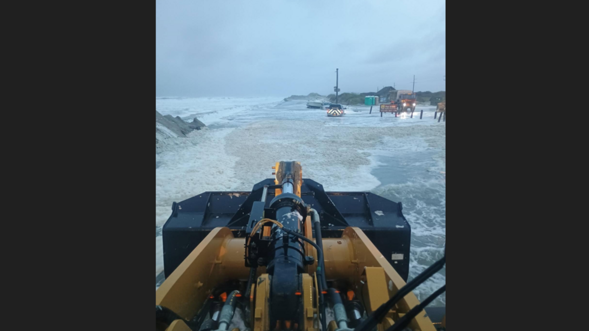
A 14-mile stretch of North Carolina’s coastal highway was closed early Thursday after a “life-threatening” coastal storm breached dunes at the Pea Island Visitor Center, according to the N.C. Department of Transportation.
Read more Motorcyclist dies after hit-and-run crash on Watt Avenue in Arden Arcade
“Major ocean overwash” is reported on N.C. 12 between the Basnight Bridge to Rodanthe, state officials said.
As of 10:30 a.m. Thursday, about 500 feet of undermined and/or broken pavement was reported near the Pea Island Visitor Center with NCDOT expecting an update once the water clears.
As of 8 a.m. Thursday, water and sand was also on the road in Ocracoke, Buxton and Hatteras but those sections are still passable, according to NCDOT. Portions of N.C. 12 were also closed for parts of Wednesday night into Thursday, and similar overwashed conditions are expected over several high tide cycles, according to NCDOT.
The closure comes as a slow moving storm continues to gain strength in the Mid-Atlantic, the National Weather Service says.
18-foot wave recorded
Forecasters say wind gusts near 60 mph can be expected off the northern Outer Banks, “with significant wave heights as high as 15 to 17 feet in the nearshore coastal waters.”
On Thursday morning, a buoy off the state line between Virginia and North Carolina recorded a wave of 18 feet, 7 inches, the National Buoy Data Center reports. An 18-foot wave was recorded off Nags Head, the center said.
Breaking waves on Outer Banks beaches could be 8 to 12 feet in height, resulting in coastal erosion, officials said.
‘Life-threatening beach hazards’
The National Weather Service has issued wind advisories, coastal flood warnings, a high surf advisories and a high rip current risk warning for the Outer Banks. The greatest coastal impacts are expected during high tide around 6:30 p.m. Thursday and 7 a.m. Friday, according to a 10 a.m. weather briefing from the National Weather Service’s Morehead City office.
“Gale-force winds and hazardous seas are expected to impact the region from North Carolina to New Jersey,” the U.S. Coast Guard said in a news release.
Read more Michaela Edwards created a playbook of academic success for young men of color
“These conditions create life-threatening beach hazards, such as dangerous rip currents and large battering waves, particularly along the coastal waters of Virginia and North Carolina.”
The storm will begin moving northeast toward New England late Thursday into Friday, the National Weather Service reported Thursday morning.
“Widespread moderate-to-locally major tidal flooding (inundation of 2-3 feet above ground level) will continue through at least tonight’s high tide, with some degree of tidal flooding likely continuing through part of the weekend,” forecasters say.
The hazardous seas could capsize or damage vessels, and many beaches put our double red flags state that no swimming is permitted due to dangerous ocean conditions.
The National Park Service has told visitors to stay out of the ocean off Cape Hatteras National Seashore, and to avoid the beach in northern Rodanthe, where seaside homes may fall in the ocean due to erosion. Multiple homes have collapsed in recent years, leaving dangerous debris spread for miles.
How to watch the storm and waves on NC’s coast
There are a number of live webcams along the coast that can provide a glimpse at the storm and waves, though some may need time to buffer.
Here are a few along the Outer Banks:
- Kitty Hawk: Twiddy & Company Vacation Rentals has a 24/7 live camera at Kitty Hawk, with a static video of the real-time ocean waves and weather.
- Jennette’s Pier in Nags Head: The North Carolina Aquarium has four different static images along the state-owned Jennette’s Pier that shows waves lapping up around the pier pilings and on the pier itself.
- Hatteras Village: Durant Station Condominiums provides a live feed near Hatteras Village, following big waves as it comes in.
- Avon Pier: The Blue Crab House in Avon has a camera of the beach near the Avon Pier.
- Highway 12: The North Carolina Department of Transportation has several live videos of conditions along N.C. 12 including where a portion of the road was closed Thursday morning
Surfchex, a website started by a Wilmington meteorologist, also compiles several live cameras on many North Carolina beaches and other state waterways.
Portions of this story were previously reported by The News & Observer.
This story was originally published September 24, 2026 at 4:53 AM with the headline “Parts of NC 12 closed on Outer Banks as 18-foot waves recorded, officials say.”
Read more Sacramento health non-profit fundraiser celebrates indigenous culture and foods