 By admin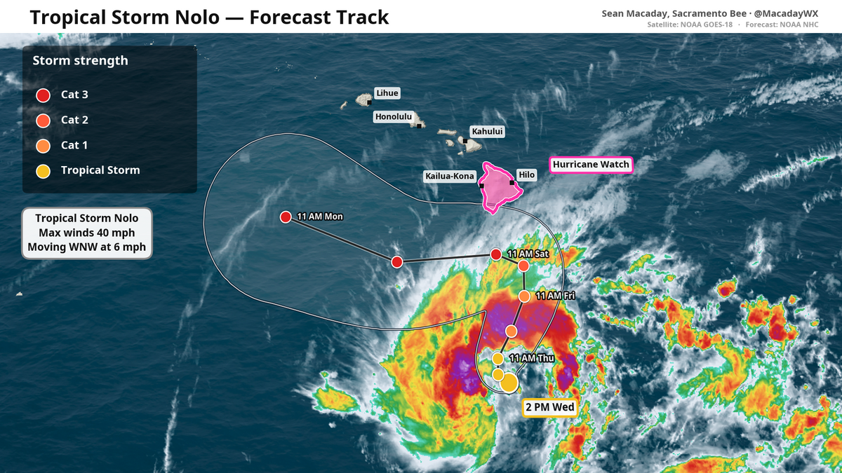
Tropical Storm Nolo formed early Wednesday afternoon in the Pacific Ocean south of Hawaii, and is expected to quickly strengthen as it approaches the state over the coming days. It is expected to bring feet of rain, flooding and strong winds to the Big Island.
Read more Roseville executive pleads guilty to $2.3 million wire fraud scheme
In the National Hurricane Center’s 2 p.m. Pacific update, Nolo had maximum winds of 40 mph and was located directly south of the Big Island.
Over the coming days, Nolo is expected to quickly intensify into a major Category 3 hurricane with maximum winds of 120 mph as it nears the southern side of the Big Island. As the storm draws close, its rain bands will begin to whip the Big Island’s southern and eastern sides with intense elevation-boosted rainfall. As winds are forced up to 13,000 feet along the steep slopes of Mauna Loa and Mauna Kea, rapidly condensing air will squeeze out extra precipitation thanks to orographic lift. During Hurricane Lala last month, more than 3 feet of rain fell across a wide area, with the highest confirmed rain total of 43.5 inches coming at Laupāhoehoe on the Big Island’s eastern shore.
A direct impact — with the storm’s center moving over land — is unlikely but not out of the question. Flood watches have already been issued by the National Weather Service for the Big Island and Maui, Lanai, Molokai and Kahoolawe. A hurricane watch has been issued for the Big Island starting Friday morning, when waves could reach up to 14 feet.
Google’s WeatherNext2 model — a state-of-the-art AI weather model that has excelled in tropical cyclone forecasting as of late — has the storm staying offshore in nearly all of its ensemble scenarios, where each run of the simulation is given slightly different initial conditions. This agreement is a good sign that Nolo will threaten the Hawaiian Islands with rain, but is unlikely to make landfall.
Newly formed Tropical Storm #Nolo will be the third hurricane to come awfully close to a landfall in Hawaii this season. And while a direct landfall is not likely, it will again bring intense rains. Hurricane watch up for the Big Island. pic.twitter.com/GZW0krGBsz
Read more Sacramento standoff on Howe Avenue ends with woman’s arrest after 3 assaulted
— Sean Macaday (@MacadayWX) September 23, 2026
Major Hurricane Polo moves towards Baja California
Still a major Category 4 hurricane, Polo has weakened some from its explosion into a Category 5 yesterday. Maximum winds of 145 mph are still swirling around Polo’s center just 140 miles off the coast of the Mexican state of Guerrero.
Polo will continue to move west over the coming days before taking a sharp turn to the north as it moves to Baja California, where a direct hit from a hurricane is looking increasingly likely early next week.
By Wednesday next week, the moisture plume from the weakening storm will arrive in Arizona and New Mexico with the potential for flash floods and lingering tropical showers throughout the desert.
El Niño will continue to churn out more storms
This intense year for hurricanes in the Pacific Ocean is brought about by El Niño, which is ramping up ocean temperatures along and near the equator south of California, and priming the greater eastern Pacific atmosphere for quickly developing tropical systems.
While Polo and Nolo — whose rhyming names are a complete coincidence — are kicking, Hurricane Odalys is also active directly between them both. And with El Niño showing no signs of slowing down, more storms are likely into October.
Read more Baby gear, toys sold in California recalled for safety risks. What to know