 By admin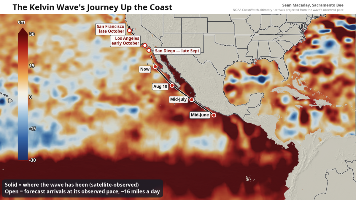
If you have not heard the term “Kelvin wave” before, you are not alone. The waves are a feature of fluid dynamics that the vast majority of the population rarely needs to worry about.
Read more 3 Bold Steelers Week 1 Predictions Against the Falcons
But you might be hearing that term more and more in the next month.
That is because something unusual is sliding up the west coast of Mexico right now, and it is aimed squarely at California. A mass of warm, elevated ocean water hundreds of miles long is moving north at roughly 6 mph — about the pace of a jogger — and currently less than 350 miles from Southern California’s beaches. And yes, it’s a Kelvin wave of sorts.
To be more scientifically correct, this is a “coastally trapped wave” and it is one of El Niño’s signature features. This one was born months ago in the far western Pacific Ocean, where bursts of westerly wind along the equator shoved a pulse of warm water eastward across the entire ocean — the pulse being the Kelvin wave. When that pulse ran into Central America early this summer, portions of it were forced to turn left and begin hugging the coastline north, glued to the coastline by El Niño’s buildup of warm water and the Earth’s rotation.
The majority of this coastally trapped wave sits deeper in the ocean. The original pulse of warm water is so thick, that it pushes the extra El Niño warmth down in a “downwelling” Kelvin wave. That deep warmth raises sea levels and cuts off the normal upwelling that typically keeps the waters along the eastern coast of the Pacific cooler that you might otherwise expect.
Satellite altimetry has tracked its progress the whole way. The bulge passed Acapulco in mid-June, Puerto Vallarta in mid-July and the tip of Baja in early August. This week it is centered off central Baja California. Inside the wave, sea levels are running roughly 4 to 8 inches above normal, and water temperatures off Baja have been measured in the mid-80s.
It continues north, now sitting at about 300 miles south of Southern California’s beaches and drawing closer by the day. At its current pace, it will arrive in San Diego by late September, Los Angeles shortly after that, and San Francisco around mid-to-late October.
Read more Rey Mysterio Teases Final WWE Run With Dominik and Aalyah Before Retirement
What a few inches of ocean means for coastal flooding
A few inches of extra ocean may not sound like much, but coastal flooding is a game of margins stacked on margins. The wave itself will not flood anything on its own — this is not a tsunami, and there will be no moment when it “hits.” Instead, it quietly raises the baseline the tides ride on top of for weeks or months at a time.
That matters most during the highest tides of the month. When a peak high tide arrives, typically around full and new moons, with the baseline already elevated, water that normally stops at the top of the beach finds its way into parking lots, bike paths and low-lying streets. Expect the National Weather Service to lean on coastal flood advisories around the high-tide windows once the wave settles in, and expect bigger wave run-up and faster beach erosion any time a swell arrives.
For Sacramento and the Delta region, the connection is closer than it looks on a map. The Delta is tidal, and in early fall — when river flows are near an annual low — the ocean’s twice-daily pulse reaches all the way up the Sacramento River to downtown. A higher ocean at the Golden Gate Bridge also translates into a smaller but measurable lift in water levels through the Delta’s leveed margins upstream. It also shifts the balance in the ongoing tug-of-war between river outflow and salty bay water pushing inland.
Meanwhile, temperatures along the coast will quickly warm. The warmest ocean temperatures ever recorded along California are not out of the question for San Diego later this month or next, running 5 to 10 degrees Celsius above average as the coastally trapped wave reaches the beach. For the Central Coast, ocean temperatures near San Francisco, currently around 55 to 60 degrees, could warm to near 70 degrees. This marine heatwave will be severe, and could have snowballing effects for the marine ecosystem into winter.
Meanwhile, the Golden State is expecting more rain this winter season thanks to El Niño, meaning that any boosted high tides could find themselves pushing up against extra rainfall coming off the land.
Read more ESPN’s Computer Defends Keeping Ohio State at No. 1 Overall